By Marcin Wojtyczka
20 minutes readAt what size do waves get big enough to cause trouble for your boat.
Wave development
Waves are created by wind blowing across the surface of the ocean. Generally speaking, the stronger the wind, and the more time and distance the wind has to blow, the larger the waves generated. Wind in itself does not pose an enormous threat until it reaches quite severe strength. Waves contain much more power and are of more concern for offshore sailors.
Wave characteristics
There are a lot of factors which influence sea state and how uncomfortable or dangerous the waves are:
- Wind speed (strength): the stronger the wind, the more power it will put into the waves and the bigger they will be
- Wind duration: the longer the wind blows, the bigger the waves
- Fetch: the longer the distance a wave travels, the bigger it will grow
- Wind direction: a steady wind direction will create a long swell from one direction. If the wind direction changes or meet a cross sea (waves from another direction), the sea will become “confused” (random waves appearing from unexpected angles) and might break. A breaking wave is one whose base can no longer support its top, and it collapses.
- Shape of the seabed: waves which have developed in deep water (water deeper than one-half of the waves length) will be severely constrained when they reach shallow water (e.g. shallows, reefs, continental shelves, seamounts - underwater mountain ranges) on the open ocean like Gorringe Ridge off the west coast of Portugal. At the point where the depth of the water is one-half of the wave’s length, it begins to “feel” the bottom. The wave will slow down, grow taller and become shaped like peaks. These wave peaks reach a height where they become unstable and, moving faster than the water below, they break forward. Adjust your ocean route to allow 10 miles between you and any seamounts that come within 30 meters of the surface.
- Water depth: shallowing bottom may create dangerous surf but if the water depth is relatively low over a large area of many miles offshore you will experience shorter and steeper but much smaller waves than in the open ocean. The old adage says that waves tend to be smaller in shallow water areas like lakes or shallow seas compared to deeper ocean waters. In shallow water, waves interact with the bottom, causing them to slow down (so they become shorter) and their energy to dissipate. The water in the hundred-odd miles wide channel between the Great Barrier Reef and the mainland in Queensland can become very rough, but in some places, there is a coral shelf at a depth of between three and six meters for many miles offshore where the waves will be small. Another example is the Baltic sea which develops a warm surface layer during summer months. To the shallow warm surface layer, the denser cold water which lies below acts like a dynamically soft shallow bottom, and prevents waves from becoming big.
- Precipitation: a torrential downpour can tremendously dampen the waves by inhibiting the production of the small capillary waves that foster the larger ones. In the torrential rain of tropical squalls this effect can lead to an almost calm sea in 40kt of wind, with only the prevailing swell remaning.
- Air temperature: cold air is denser than warm air and so creates a greater force. Consequently, cold wind makes bigger waves than warm wind. The force on the boat from cold wind can be even 20% or so higher than that of warm wind.
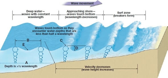
In general, if the water depth is about 2 to 3 metres, waves in winds up to about 10 knots will be unchanged compared to deep water. Waves in winds from 10 to 25 knots will be higher and steeper. In winds stronger than 25 knots, waves become very steep and can even break in shallow areas if there is enough fetch but the maximum height of the waves becomes limited. For example, sustained 40 knots of wind can develop waves 10 to 12 metres high in the North Atlantic, but only 2 to 3 metres in the Great Lakes and the Baltic Sea in late summer. This is because the denser cold water below the warm surface layer continues to act like a shallow bottom, and big waves cannot develop in shallow water.
- Tide or current: the wind causes a surface current of its own. A wind that has blown from a steady direction for several hours kicks up a current of about 2 percent of its speed. A 25-knot wind may create a 0.5-knot current. The wind blowing and the generated current against the direction of the tide can create a much worse sea state than you might expect purely from the wind speed (2 knots of contrary current can double a wave’s height). In some parts of the world, a wind force greater than 4 over tide can create unnavigable conditions (e.g. South-East coast of Africa). Moreover, if you consider the fact that 1 knot of current is worth 10 kt of wind there are serious forces to go against.
Waves vs Swell
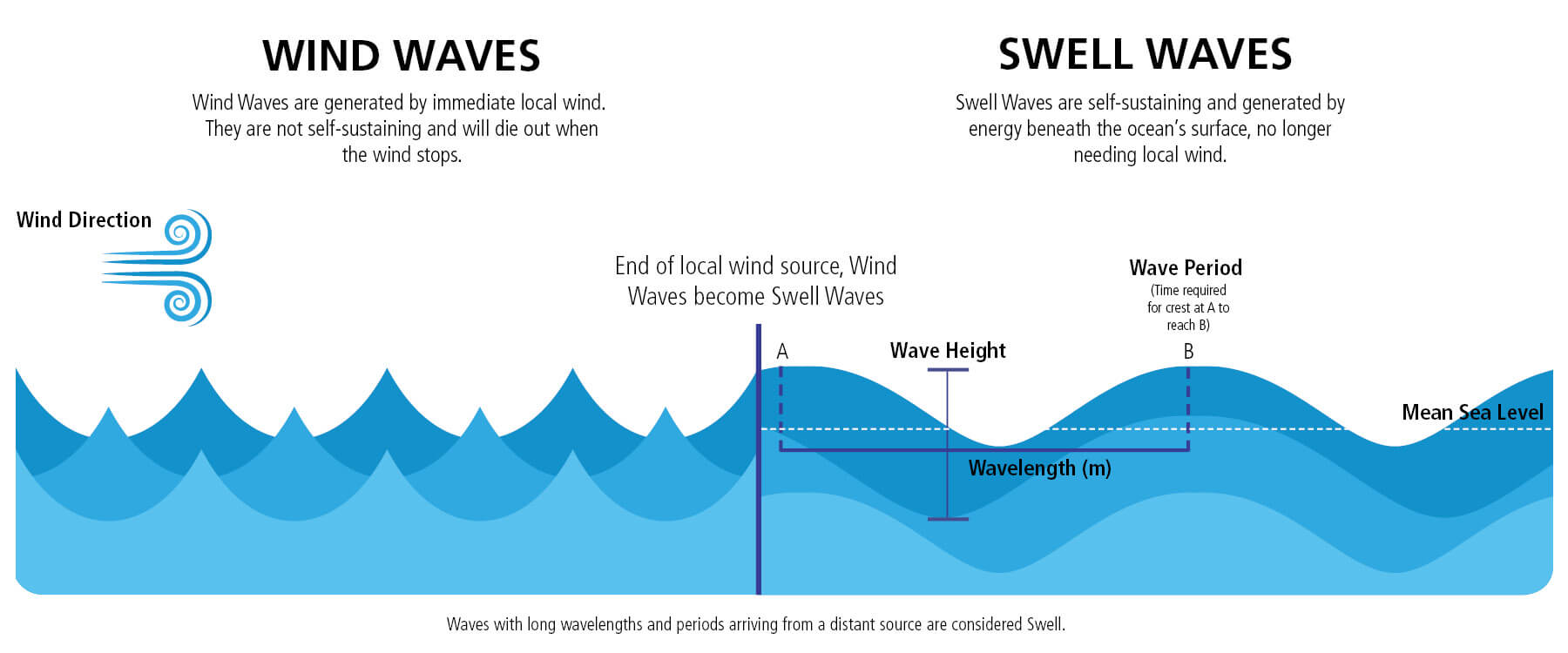
Waves caused directly by the local wind are called wind waves. Wind waves are short, choppy, and tend to break. This is because the underlying water is not yet moving at speed with the wind. After the wind has been blowing for 48 hours or more, the waves become less steep and their velocity and period increase. When the waves eventually travel outside their generation area and are no longer the result of the local wind, they are called “swell”. Swell tend to move faster than the storm and leave the general area of the storm.This is similar to the way in which the ripples caused by the rock landing in the pond travel away from the rock’s impact location and move towards the shore.
Compared to wind waves, swell waves are longer with smoother crests. Swell is unlikely to produce breaking waves unless a strong current is going against it, or it goes over a shallow sea bed (e.g. reef, continental shelf, bank, coast).
Dangerous wave conditions
A cubic metre of water weighs one tonne, and water does not compress easily so when large waves start to land on deck or push the boat around, they can cause enormous damage. So, in most cases, it is the sea state rather than the wind which needs to be wary of.
Most sailors would be surprised at the minimal wave height needed to roll a boat. Andrew Claughton (who co-authored the University of Southampton, Department of Ship Science’s report) writes in Adlard Coles’ Heavy Weather Sailing, “During the model tests that were carried out to investigate the problem, when the breaking wave was 30 percent of the hull length high, from trough to crest, it could capsize some yachts, while waves to a height of 60 percent of the hull length comfortably overwhelm all the boats we tested.” So, the starting point for a breaking wave to be dangerous to rolling a boat is one that is only 30 percent high as the boat is long.
Breaking waves normally develop only when something opposes the movement of wind-driven waves, causing them to rise up like waves on a beach. As they get higher and steeper, the crest of the wave becomes unstable and begins to collapse down its face, just as happens with a surfing wave. Boats pitchpoling or rolling is almost always associated with breaking waves.
Whitecaps or cresting foam and whitewater do not constitute a danger to a well-found boat. But breaking waves change the situation completely. Your boat may be more or less susceptible to rolling than other boats based on its design, but the aspects to remember are that although your boat may be severely tilted over by the wave, for the wave to knock the boat down or completely roll over (even worse pitch pole) all the below need to happen at the same time:
- Wave height must exceed 30% of the yacht length (risk of pitchpoling) or must match the beam of the boat (risk of knock-down and rolling)
- The boat needs to be broadside or oblique to the wave
- The boat needs to be struck by a breaking wave: unless the wave is breaking, the boat should ride up and over the wave regardless of the wave height in comparison to the boat length and the boat’s orientation to the wave
When the wave height reaches 50% of the boat length, there is a high probability of capsizing, with more than 60% the boat is going to be capsized every time! (of course only if broadsided and with breaking waves).
Weather forecast parameters to pay attention to
Wave height
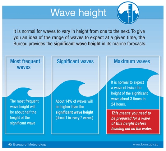
Wave height is the distance measured from the trough to the crest of the wave. The wave forecasts typically show significant wave height (SWH), which is the average height of the highest one-third of all waves measured. A theoretical maximum wave height possible is approximately equal to two times SWH!. So when the marine forecast says seas 3 m you should expect waves up to 6 m. Example for SWH of 3 meters:
Wave period
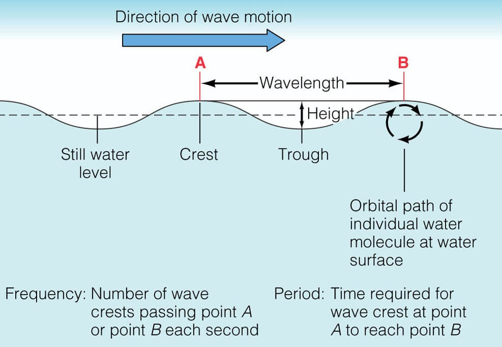
A wave period is a time that elapses between the passing of successive crests or troughs. The longer the wave period the bigger the wave and the stronger the wind that caused it. The shorter the period, the more chance of breaking waves to occur. Note that breakers can occur even with a long wave period if the waves begin to “feel” the bottom or approach moderately steep shores.
As waves move farther away from their source region, their wavelength and period gradually increase. Therefore, waves with long periods, greater than 10 or 12 seconds, are arriving from a distant source and are considered swell. The swell period determines how fast a swell will propagate across the open ocean.
Formulas:
- Wave speed in knots = 1.5 x period in secondes
- Wave speed in knots = 1.34 x square root of wavelenght
Typical waves in the Atlantic have a period of 6-8 seconds and travel at 12 knots (1.5 x 8). A period of 9-15 seconds might be an indicator of TRS’s existence. A swell with a period of 9 seconds will travel at 13.5 knots, while a swell with a 15-second period travels at 22.5 knots!
As we know, wind causes ocean waves. However, fully developed waves do not grow linearly with wind speed (see here). If nothing else, as a general guidance, you can assume that developed wind waves move in the direction of the wind at about 0.7 times the wind speed. Therefore, a wave in 10 kt of wind would be moving at about 7 kts.
Wavelength
Wavelength is the distance between successive crests or troughs. It is harder to measure than wave period, and unfortunately, it is not included in modern weather forecasts. You can use the below formulas for deep water to get a rough estimation based on wave period.
Formulas:
- Wavelength in meters = (g x square of period in secondes) / (2 x π) ~ 1.56 x square of period in secondes
- Wavelength in feet = 5 * x square of period in secondes
Typical waves in the Atlantic have a period of 6-8 seconds and a wavelength of 100 m (1.56 x 8 x 8).
In shallow water, the wavelength and period decrease significantly as explained in this video.
Wind gusts
Not a wave parameter but quite an important one as a big difference between regular wind and gusts may cause shock stress and damage the rig and sails.
Remember that weather forecasts are just forecasts. You probably realize from your own experiences that weather forecasts are not exact and can sometimes be way off. A prudent approach is to apply 30% or so of the safety margin to the predicted conditions. As an example, if you see a predicted wind of 30 kt you can expect 40 kt or even more, especially in areas where the wind could be funnelled or accelerated by steep coast (e.g. West coast of Portugal, Canaries acceleration zones).
Predicting breaking waves
Predicting dangerous breaking waves is complex. The best information that most sailors will have to rely on is the weather report. The wave height and the wavelength (or wave period) are the two pieces of critical information. Once you know them, you can determine whether the waves will have the potential to be breaking or not.
A wave will break, or collapse, depending on the wave’s steepness. The base of the wave (the wave’s length) can only support a wave of a certain height. If it exceeds that height, the wave becomes too steep, and it collapses and breaks forward. This is called the wave’s breaking point.
- Rule 1: If a wavelength is 7 times or less than the wave height, then the wave may break.
- Rule 2: When the water depth is approximately 1.3 times the wave height, the wave may break.
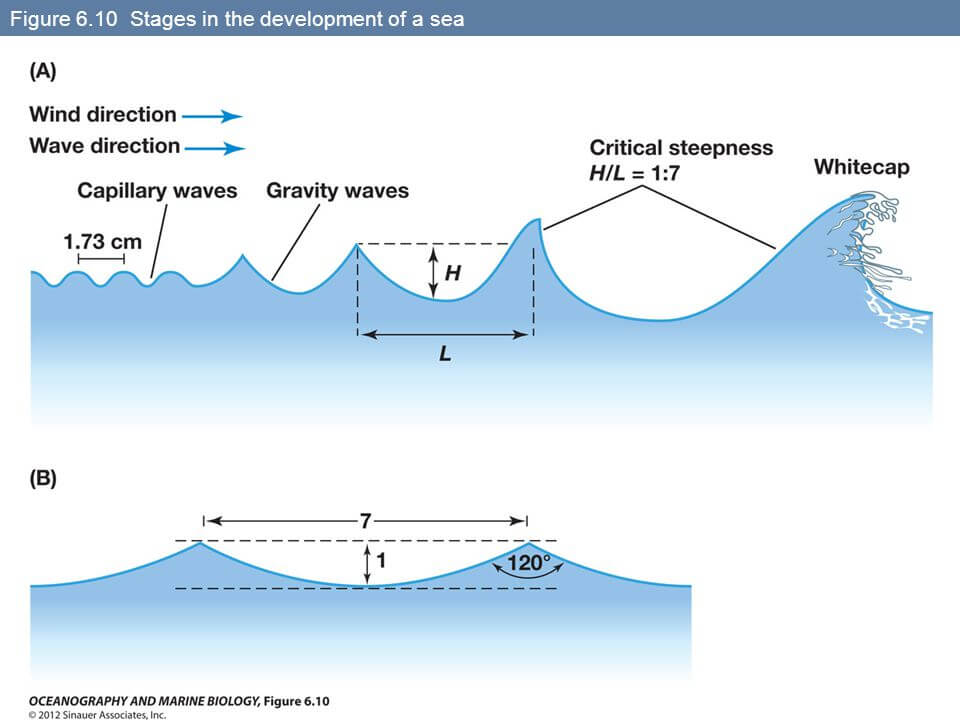
Take into account that near-shore waves are less predictable and tend to break more often due to shallowing sea bottom. Great for surfing but not sailing. Be very careful when approaching harbours from the open sea if the sea state is high. The weather forecasts are not taking shallow water into consideration, so you have to judge this yourself. All banks and patches should be avoided in swell conditions. It should be remembered that the depth of water is reduced by half the height of the swell and that the swell increases in height as the water gets shallower. Entering a shallow harbour entrance in a swell should only be attempted on the flood and near HW.
Areas prone to breaking waves
Gale force winds usually don’t produce breaking waves. However, they are more prone to occur in one of the below cases:
Shoaling waters: when large waves fetch up against the continental shelf or shallow banks, the waves rise up and roll. Note that a fast ferry can also develop a large wash that when it reaches shallow water can become dangerous. It is therefore wise to avoid shallow water in the vicinity of routes where such ferries operate at high speed.
Wind against current (e.g. Low-pressure systems and strong ocean current): a system that would normally pose little hazard can create dangerous breaking waves where wave and strong current conflict (e.g. Gulf Stream or Agulhas Current). When heading up the US East Coast or down the eastern coast of South Africa, sailors want to take advantage of the 3-4 knots boost from the current without finding themselves in the dangerous waves a low can bring.
Wind against tide: When the wind blows against the tide the waves become steeper and break, but when the tide turns the waves flatten and lengthen giving much more pleasant conditions. This effect can change the sea state enormously and strong winds should always be considered.
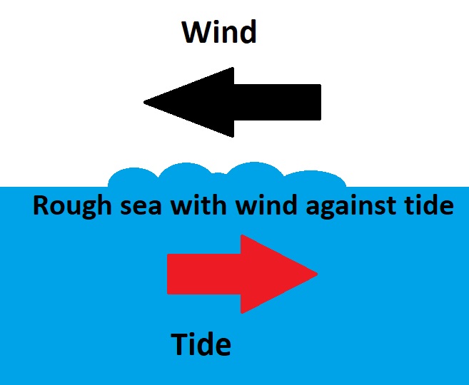
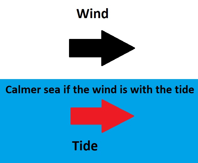
Large swell against waves moving in opposite direction: large cross seas can combine to produce steep and dangerous seas.
Sudden wind shift: near the centre of a very deep low-pressure system, the winds tend to shift violently from one direction to another. The new wind-driven waves will run in opposition to the existing waves created by the previous wind. Strong winds from 8 Bft, creates confused seas with random breaking waves. This most often happens at the centre of tropical revolving storms.
Waves with different frequencies overlapping: as known from the physics theory, when two waves with different frequencies overlap, it produces a cycle of alternating constructive and destructive interference between waves (e.g. to be expected in the Southern Ocean).
Tidal Races: When a tide runs it can affect the sea state and produce either calmer or rougher conditions than expected. On some charts there is a warning about tide races in the area covered by that chart, these can be potentially dangerous places. Off virtually any headland you can expect some sort of race when the tide runs, some of these races are minor but most require some care. If they are passed at least 2-5 miles offshore the vessel is normally outside the danger area. Some headlands can be passed very close to the shore, where there may be an area of calmer conditions at certain times of the tide, these passages should only attempt by experienced sailors or those with local knowledge.
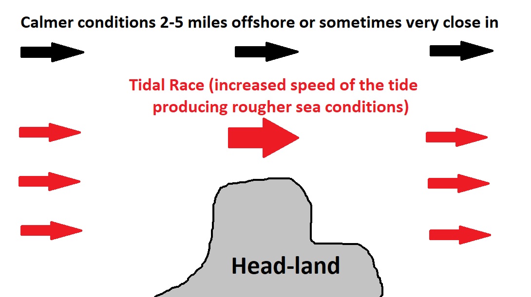
Tide races will occur anywhere that the speed of the tide is accelerated by a constriction, such as a headland or narrowing in the channel. This increase may produce currents of 10 or more knots in localised areas, probably far more than the official information indicates. In these conditions, great care must be taken with the navigation as the vessel’s position may be changing too fast for conventional navigation techniques.

- Overfalls: Overfalls will occur when the tide flows over a shallow patch on the seabed, often this is within a tide race! The rough water is normally found on the down tide side of the obstruction.
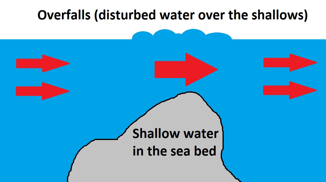
Whenever a current flows over an obstruction in shoal water or an abrupt change of depth, a wave will form. The restricted area through which the current can flow forces an increase in the current speed. As per the Bernoulli’s principle when the speed increases the pressure reduces, and the level of the surface drops. Where the flow leaves the obstruction the flow reverts to its earlier lower speed. The impact of the faster current against this slower water creates a local pressure which forces the surface water upwards. If the bottom is relatively shallow for some distance, and sufficiently uneven, the result will be a series of standing waves (aka overwalls).
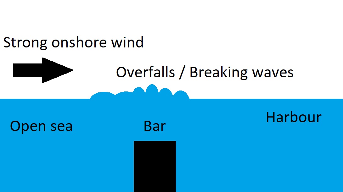
- Harbour Bars: A bar is a shallow entrance normally found just outside the harbour entrance which may be quite deep. The danger of this shallow area is that when there is a swell and/or onshore wind the waves might break right across the entrance. If the tide is flowing strongly out of the harbour such as on the spring ebb tide this effect is exaggerated and the waves will be very close together and may produce conditions in which no yacht could survive. If a harbour has a bar on the entrance it should be treated with caution. When in doubt call the harbourmaster before coming in. Before going out, check the conditions at the entrance.
Determining boat danger zone
To determine dangerous wave heights and lengths for your boat, the two formulas need to be met:
- Wave Height >= 30% of Boat Length (risk of pitchpoling) or match the beam of the boat (risk of knock-down and rolling)
- Wave Length <= Wave Height x 7
You can use that formula as a general rule but note that the danger presented depends on the boat design and is unique to each vessel.
Example 1. Boat 40 feet long, 3.6 m beam, significant wave height 1.8 m/6feet (Hmax 3.6 m), wave period 6 sec (wavelength = 1.56 x 6 x 6 ~56 m), deep water.
Using the minimum 30 percent wave height to boat length, if your boat is 40 feet (12 m) long and 3.6 m wide, then the wave-height danger zone starts at waves 3.6 m high (0.3 x 12 m), SWH of 1.8 m/6 feet. A wave 3.6 m high could knock down the boat (throw the boat over to 90 degrees or more) if caught somewhere near the beam onto the wave as it breaks. Following the Rule of 7 or less, you know that a 3.6 m wave could break only if the wavelength is less than 25 m (3.6 m x 7), 4 sec wave period. So, these conditions should not present a danger to the boat in the deep sea.
Example 2. Boat 40 feet long, 3.6 m beam, significant wave height 2.5 m/8feet (Hmax 5 m), wave period 6 sec (wavelength ~56 m), deep water.
The boat is within the wave height danger zone (5 m Hmax > 0.3 x 12 m = 3.6 m) and not within the wavelength danger zone (56 m wavelength> 7 x 5 m = 35 m). So, these conditions should not present a danger to the boat.
Example 3. Boat 40 feet long, 3.6 m beam, significant wave height 3.2 m/10 feet (Hmax 6.4 m), wave period 6 sec (wavelength ~56 m), deep water.
The boat is within the wave height danger zone (6.4 m Hmax > 0.3 x 12 m = 3.6 m) but not within the wavelength danger zone (56 m wavelength> 7 x 6.4 m = 45 m). So, these conditions should not present a danger to the boat even though some may find these conditions worrisome. However, if the conditions are harder than predicted by 20%, it will become dangerous to sail in these conditions. It’s your call, but a prudent sailor would consider this dangerous.
Example 4. Boat 40 feet long, 3.6 m beam, significant wave height 4.2 m/13 feet (Hmax 8.4 m), wave period 6 sec (wavelength ~56 m), deep water.
The boat is within the wave height danger zone (8.4 m Hmax > 0.3 x 12 m = 3.6 m) and within the wavelength danger zone (56 m wavelength < 7 x 8.4 m = 59 m). So, it might be dangerous for the boat to sail in these conditions.
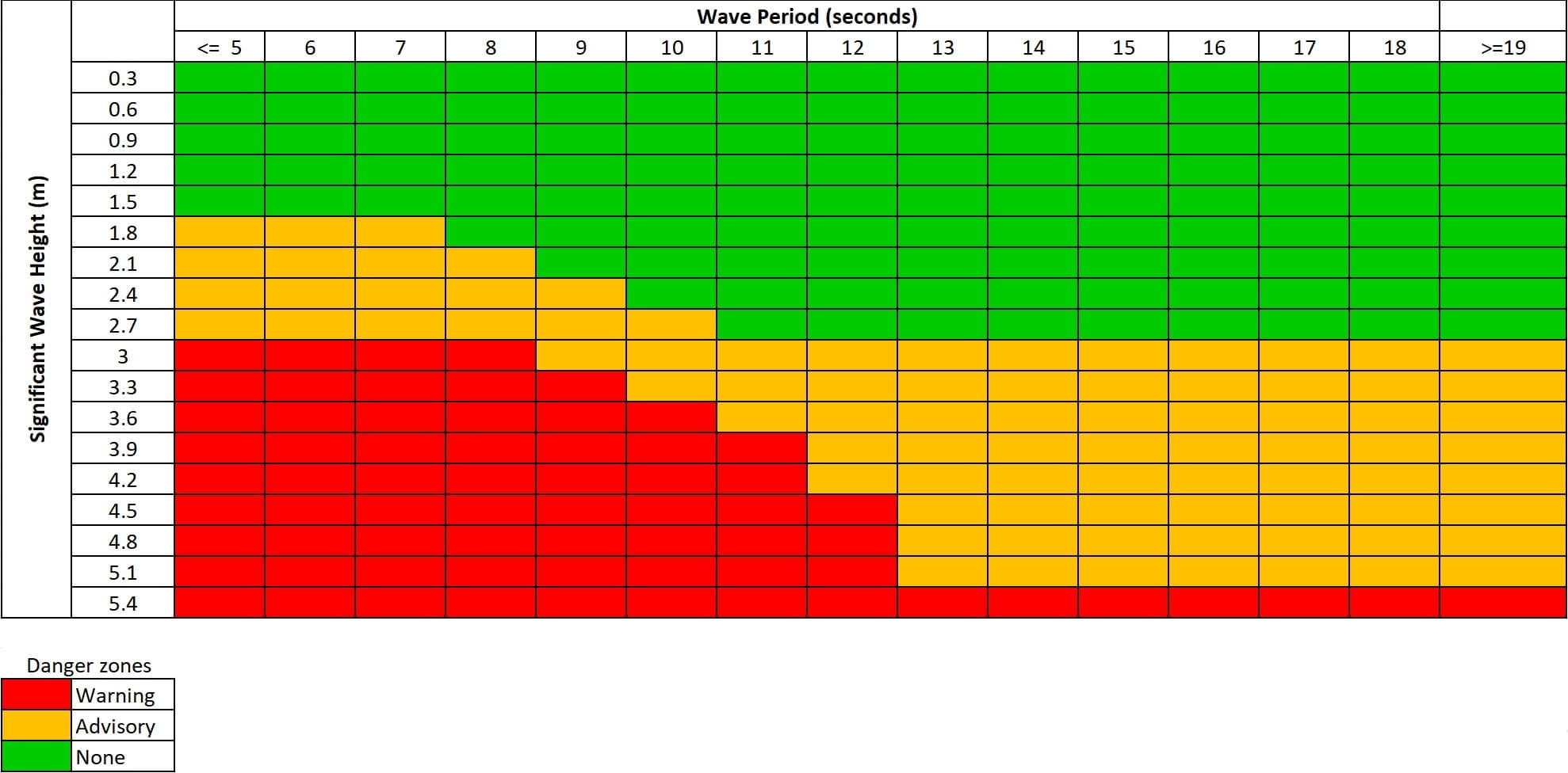
Below table can be used as guidance to indicate potential danger to vessels with a closed cockpit configuration of ~100 feet or less. The table was developed for coastal waters (within 60 nm of shore) off the US Western Pacific coast by the National Weather Service. The specific values and conditions might be different to other waters such as the Atlantic Ocean. However, an important message indicated by the table applies to all waters: for small vessels, the danger increases when the wave period/length decreases (for a given wave height).
How to avoid breaking waves
In today’s world of satellite communication and more accurate weather forecasts, it is certainly easier to avoid heavy weather than before. Sailing up a sea storm is very hard, sometimes impossible. That is why it is important to plan, execute and monitor passages properly, with a good weather forecast in your hands and an alternative strategy in your mind.
Do not head out to sea if bad weather is predicted.
You should generally stay in the harbour if bad weather is predicted. But once you are out on the sea, far from a harbour, and the forecast predicts a deep low in your vicinity, you might not have enough time to avoid the system. You can attempt to escape as far away from the low as possible, and ensure that you are some distance away from any shelving seabed which could increase the likelihood of breaking waves. Other than that, you should plan passages to avoid unfavourable seasons, e.g. hurricane season that can create Tropical Revolving Storms (TRS) that must be avoided at all costs (North Atlantic and North Pacific: July - November; Bay of Bengal and Arabian Sea: June - November; South Pacific and South Indian Ocean: November - April).
How to cope with breaking waves
The most important tactic in copying with the breaking sea is not to get caught beam to the waves. Choose a storm tactic that will minimize this. For a typical modern cruiser, this would mean running downwind and for a traditional voyager with a long keel probably heaving-to.
A really cool part of heaving-to is that the boat will leave a wake to windward. Breaking waves hit this “slick” and flatten out, thus reducing the wave action on the vessel. Modern lightweight boats generally don’t heave-to very well, and certainly not as well as a solidly built full-keel boat will. The sail plan and hull geometries of modern designs just do not let the boats lie stable to the wind. So you will have to decide depending on what works for your boat.
Fair Winds and Following Seas!
- Related articles:
- Seamanship
- Meteorology
- Boat Handling